Title

Remote Sensing - fundamentals and applications - AulaGEO

Learn the fundamentals and applications of remote sensing

4.68 (36 reviews)
Udemy
platform
English
language
Science
category
instructor
Remote Sensing - fundamentals and applications - AulaGEO
2β€―560
students
1.5 hours
content
Dec 2024
last update
$22.99
regular price

What you will learn

Remote Sensing Background

Types of Remote Sensing

Applications of Remote Sensing data

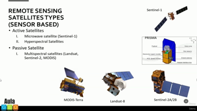
Multispectral Satellite data Microwave (Radar) Satellite data Hyperspectral, Satellite data Applications in Land Cover Applications in Agriculture

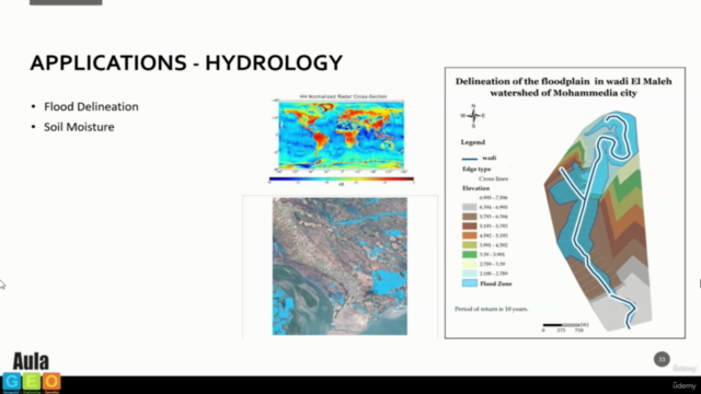
Applications in Forestry, Applications in Geology, Applications in Hydrology, Applications in Sea-ice, Applications in Oceans and Coastal

Why take this course?

🌱 Unlock the Mysteries of Earth with Remote Sensing - Your Journey to Mastering Satellite Science Starts Here!


Course Title: Remote Sensing - Fundamentals and Applications πŸš€


Course Description:

Remote sensing is a powerful tool that allows us to monitor and understand the Earth's surface by capturing data from air or space. Unlike traditional observation methods, it gives us a bird's-eye view of our planet, revealing insights that are often invisible to the naked eye. This online course, designed by AulaGEO Academy, will take you on an enlightening journey through the world of remote sensing.

What You Will Learn:

  • Earth Observation Basics: Discover how special cameras collect remotely sensed images and what these images can tell us about the Earth's physical characteristics. πŸ“Έ

  • Advanced Techniques: Explore the cutting-edge technology used in sonar, thermal imaging, and the high-resolution cameras on satellites to analyze everything from ocean floors to atmospheric conditions. πŸŒŠβ˜€οΈ

Key Applications of Remote Sensing:

  • Emergency Response & Disaster Management: Track large forest fires, monitor volcanic activity, and predict natural disasters by analyzing data collected from space. πŸ”₯🌍

  • Environmental Monitoring: Use remotely sensed images to monitor climate change effects, track cloud movements, and study environmental changes over time. πŸŒ€οΈπŸ™οΈ

  • Agriculture & Forestry: Analyze the health of crops, deforestation rates, and the effects of human activities on natural ecosystems. 🌾🌳

  • Geology & Oceanography: Map the Earth's surface features, understand geological processes, and study the ocean floor's topography with unprecedented detail. πŸ’ŽπŸŒŠ


Course Structure:

Section-1: Introduction πŸŽ“

  • Get acquainted with the course and understand the impact of remote sensing on various fields.

Section-2: Remote Sensing Background πŸ”

  • Dive into the fundamentals of remote sensing, including its principles and key concepts.
  • Journey through the history of this fascinating science.

Section-3: Types of Remote Sensing πŸ›°οΈ

  • Learn about the different types of sensors and how they influence the kind of data we collect.
  • Understand the significance of resolution and purpose in remote sensing technology.

Section-4: Applications of Remote Sensing Data 🌍

  • Discover a wide array of applications in land cover, agriculture, forestry, geology, hydrology, sea-ice monitoring, and oceans & coastal management.

By the end of this course, you'll have a comprehensive understanding of remote sensing and its multifaceted applications across different disciplines. Whether you're a student, researcher, environmentalist, or simply fascinated by our planet, this course will equip you with the knowledge to harness the power of satellite imagery and data.

Enroll now and start your journey towards becoming a remote sensing expert! 🌟

Screenshots

Remote Sensing - fundamentals and applications - AulaGEO - Screenshot_01Remote Sensing - fundamentals and applications - AulaGEO - Screenshot_02Remote Sensing - fundamentals and applications - AulaGEO - Screenshot_03Remote Sensing - fundamentals and applications - AulaGEO - Screenshot_04

Our review


Overall Course Review

The course in question has received an impressive global rating of 4.35, with all recent reviews being highly positive. The consensus among learners is that this course significantly elevates professional proficiency and is a worthwhile investment for those looking to expand their career prospects through the strategic applications of remote sensing.

Pros:

  • Elevates Professional Proficiency: Completing this course instills confidence in applying remote sensing skills in diverse scenarios, making it a key asset for professional growth.
  • Strategic Applications: The course goes beyond technical skills to highlight the strategic implications of remote sensing in shaping decisions across various fields.
  • A Wealth of Knowledge: It serves as a treasure trove of valuable information, providing learners with a solid foundation in remote sensing.
  • Tailored for Effective Learning: The course is structured to facilitate effective learning and guide learners through the acquisition of A2.1 level language skills.
  • Seamless Transition to A2.1: For those transitioning from A1 to A2.1, this course offers a structured approach that builds upon foundations laid in previous levels.
  • Real-world Scenarios Shine: The emphasis on practical applications ensures learners are well-prepared for real-world challenges within their professional roles.
  • Tailored for Practical Use: The course doesn't just teach remote sensing; it shows how to practically apply it to solve industry-specific problems.
  • Actionable Takeaways: Each module provides actionable insights that can be immediately implemented in professional projects.
  • Dynamic and Engaging Instructor: The engaging teaching style of the instructor makes learning about remote sensing an enjoyable experience.
  • Applicable Across Industries: The course's practical approach is relevant to various professional backgrounds, including environmental science, geography, and agriculture.
  • Relevant to Today's Applications: It covers the latest trends and tools in remote sensing, ensuring learners are up-to-date with current industry practices.
  • Engaging Content: The course material is engaging and ensures a dynamic learning experience.
  • Insightful and Practical: The course effectively bridges theory and application, offering valuable insights for professionals aiming to leverage remote sensing in their work.
  • Comprehensive Coverage: It spans a wide array of remote sensing topics, from fundamentals to advanced real-world applications.
  • Expert Guidance Illuminates: The instructor's clear guidance and step-by-step demonstrations create a strong foundation for applying remote sensing skills practically.

Cons:

As with any course, there is always room for improvement. However, the reviews did not highlight significant drawbacks. The following are minor considerations based on the feedback:

  • Potential for More Hands-On Exercises: Some learners may desire a wider variety of hands-on exercises to further complement the course content.
  • Customization for Different Learning Paces: While tailored for effective learning, learners with different paces might benefit from more flexibility in the course structure.
  • Advanced Topic Coverage: Learners with prior experience might find some sections of the course too elementary and could appreciate a more advanced track within the same course.

In conclusion, this remote sensing course stands out for its comprehensive coverage, expert guidance, and practical approach to learning, making it an excellent choice for professionals aiming to enhance their skill set and apply remote sensing in their current roles or industries.

Charts

Price

Remote Sensing - fundamentals and applications - AulaGEO - Price chart

Rating

Remote Sensing - fundamentals and applications - AulaGEO - Ratings chart

Enrollment distribution

Remote Sensing - fundamentals and applications - AulaGEO - Distribution chart

Coupons

DateDiscountStatus
08/02/2024100% OFF
expired
20/02/2024100% OFF
expired
28/02/2024100% OFF
expired
4590372
udemy ID
10/03/2022
course created date
14/03/2022
course indexed date
Bot
course submited by