Learn Transport Network Analysis using ArcGIS from scratch
Spatio-Temporal Analysis of Transportation Networks
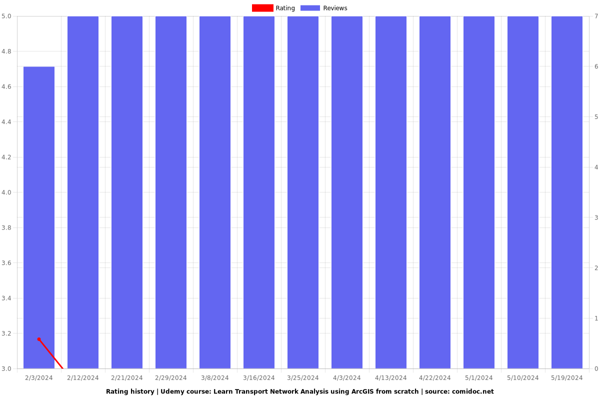
2.86 (7 reviews)

20
students
1 hour
content
Feb 2023
last update
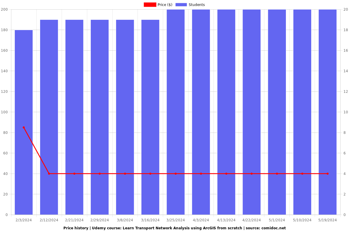
$39.99
regular price
What you will learn
Downloading and Georeferencing Raster data from GoogleEarth Pro
Mosaicking, Clipping and Digitization of Raster data
Creating and Building a Transport Network Dataset
Preparing and manipulating Transport Network data attributes
Perform Closest Facility and Service Area (Isochrone) Network analysis
Why take this course?
🚀 **Learn Transport Network Analysis using ArcGIS from Scratch** 🚦
GroupLayout: **Spatio-Temporal Analysis of Transportation Networks**
---
**Course Instructor: James Awulu**
Hey there, future GIS analysts and transportation engineers! My name is James Awulu, and I'm here to guide you through the fascinating world of Geographic Information Systems (GIS) with a specific focus on Transport Network Analysis using ArcGIS. As a GIS Analyst and Transport Engineer, I've spent years navigating the intricacies of spatial analysis across diverse sectors, fromTransportation to Agriculture and Climate, and I'm passionate about sharing my expertise and promoting GIS applications that make a tangible impact.
---
### 📚 **Course Overview:**
This course is designed for beginners and experienced practitioners alike who are eager to grasp the core principles of GIS and apply them to real-world problems, particularly in the domain of transportation. By the end of this course, you'll be able to:
- **Download Spatial Data** from a variety of sources, ensuring you have the necessary datasets for your analysis.
- **Acquire Data from GoogleEarth Pro**, leveraging its high-resolution imagery for accurate mapping.
- **Convert shapefiles (.SHP)** to the more versatile formats like .KMZ/.KML, enhancing compatibility and usability.
- **Geocode/Geo-reference Raster data**, turning raw images into actionable spatial information.
- **Mosaic multiple satellite imageries**, creating a composite image for detailed analysis.
- **Clip raster data to desired shapefile boundaries**, focusing your analysis on specific areas of interest.
- **Digitize Raster data to create a Road map**, transforming visual data into useful spatial datasets.
---
### 🔍 **Mastering Spatial and Temporal Analysis:**
Moving beyond basic GIS operations, this course will delve into the heart of Transport Network Analysis with ArcGIS, teaching you how to:
- **Dissolve road networks** for efficient data manipulation.
- **Estimate length of road networks**, tailoring your analysis to real-world traffic conditions.
- **Assign standard speeds of traffic**, customizing your model to the specific area of interest.
- **Prepare and manipulate Network attribute data**, ensuring accuracy and relevance in your spatial queries.
- **Assign closest Facilities from points of Origins to Points of Interests (Destinations)**, optimizing routes for efficiency.
- **Prepare Isochrone maps**, displaying areas of equal travel time or distance from a given point.
---
**N/B:** This course is particularly beneficial for GIS enthusiasts specializing in transportation engineering. Its structured approach makes it accessible to beginners without prior GIS experience, while still offering valuable insights for seasoned experts.
---
### 🎓 **Hands-On Learning Experience:**
This course promises:
- **Project-based tutorials**, giving you practical skills through hands-on learning.
- **Brief and explicit instructions**, making complex concepts simple to understand.
- **Comprehensive guidance**, ensuring that no matter your starting point, you'll be well-equipped to tackle Transport Network Analysis using ArcGIS.
---
Join me, James Awulu, on this journey through the world of GIS and Spatial Analysis. Let's embark on an adventure that will transform the way you perceive and interact with spatial data, particularly in the realm of transportation. Sign up today and unlock the power of ArcGIS for your next project! 🌟
Screenshots


Charts
Price
Rating
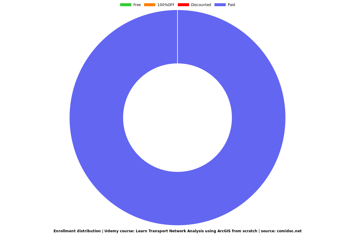
Enrollment distribution
Related Topics
5138860
udemy ID
2/5/2023
course created date
2/3/2024
course indexed date
Bot
course submited by