ArcGIS Pro - beginner, advanced and ArcPy
Learn ArcGIS Pro beginner and advanced levels

What you will learn
Learn ArcGIS Pro from zero
Create, import data, analyze and generate final maps
Learn doing, through step by step use cases - All in the same environment of data.
Learn doing, through step by step use cases - All in the same environment of data.
Why take this course?
Learn how to use the tools provided by ArcGIS Pro, starting from scratch.
This course include, the basic of ArcGIS Pro; data edition, methods to selection of spatial data based in attributes and location and creation of bookmarks. Then, we include digitization of shapefiles, addition and digitizing layers, editing attribute and column attributes.
You will learnt to use symbology within features and labeling of points, lines and polygons. Includes buffer analyisis, import of Excel data and georeference of images.
To share data you will learn how to share data online and generate final maps.
Includes step by step excercises in the AulaGEO environment.
Learn how to use the advanced aspects of ArcGIS Pro:
Handling of satellite images (Imagery),
Spatial databases (Geodatabse),
Management of LiDAR point clouds,
Content publishing with ArcGIS Online,
Applications for mobile capture and visualization (Appstudio),
Creation of interactive contents (Story maps),
Creation of final contents (Layouts from .mxd and from scratch).
Python programming in ArcGIS Pro
#AulaGEO The course includes databases, layers and images used in the course to do what appears in the videos.
The entire advanced sections are applied in a single context according to the AulaGEO methodology.
Content:
Introduction
Lecture 1: Introduction
Lecture 2: Data selection
Lecture 3: Use bookmarks
Creating and editing spatial data
Lecture 4: Import data from Excel
Lecture 5: Symbology data
Lecture 6: Editing of attribute data
Lecture 7: Labeling features
Lecture 8: Digitization of geographic information
Lecture 9: Georeferencing of images
Analysis data
Lecture 10: Buffer analysis
Publishing contents from ArcGIS Pro
Lecture 11: Map generation
Let´s do it in AulaGEO - step by step excercises
Lecture 13: Let´s do it in AulaGEO - step by step excercises
Lecture 14: Exercise 1. Import CAD data to GIS
Lecture 15: Exercise 2. Import coordinates from Excel for split a polygon
Lecture 16: Exercise 3. Calculation of areas and composition of calculated fields
Lecture 17: Exercise 4. Buffer Analysis
Lecture 18: Exercise 5. Attribute labeling
Lecture 19: Exercise 6. Thematization by attributes
Lecture 20: Exercise 7. Digitization tricks
Lecture 21: Exercise 8. Gereferencing images
Advanced analysis
Lecture 22: Working with satellite images
Lecture 23: Creation and management of Geodatabases
Lecture 24: Working with point clouds - LiDAR
Generation of products for users
Lecture 25: Share content with ArcGIS Online
Lecture 26: Interactive content - StoryMaps
Lecture 27: Create applications - AppStudio for ArcGIS
Lecture 28: Creation of Layout from a .mxd
Lecture 29: Create Layout from scratch in ArcGIS Pro
Python programming in ArcGIS Pro
Lecture 30: Run python script from outside ArcGIS Pro
Lecture 31: Introduction to python window
Lecture 32: Run buffer analysis tool
Lecture 33: Field management tool & Length Calculation
Lecture 34: Use Arcpy for Get result form tool, wo…ta properties
Lecture 35: Import Arcpy and modules
Lecture 36: Describe properties of data
Lecture 37: Create a field list and loop through the contents
Lecture 38: Geo processing and select by location tools
Lecture 39: List unique values from attribute table Ordenados por nombre
Lecture 40: Map document ot pdf map conversion
Lecture 41: Split Line to Multiple Parts
Bonus lesson
Lecture 42: Image segmentation
Lecture 43: Image clasification
Screenshots


Reviews
Charts
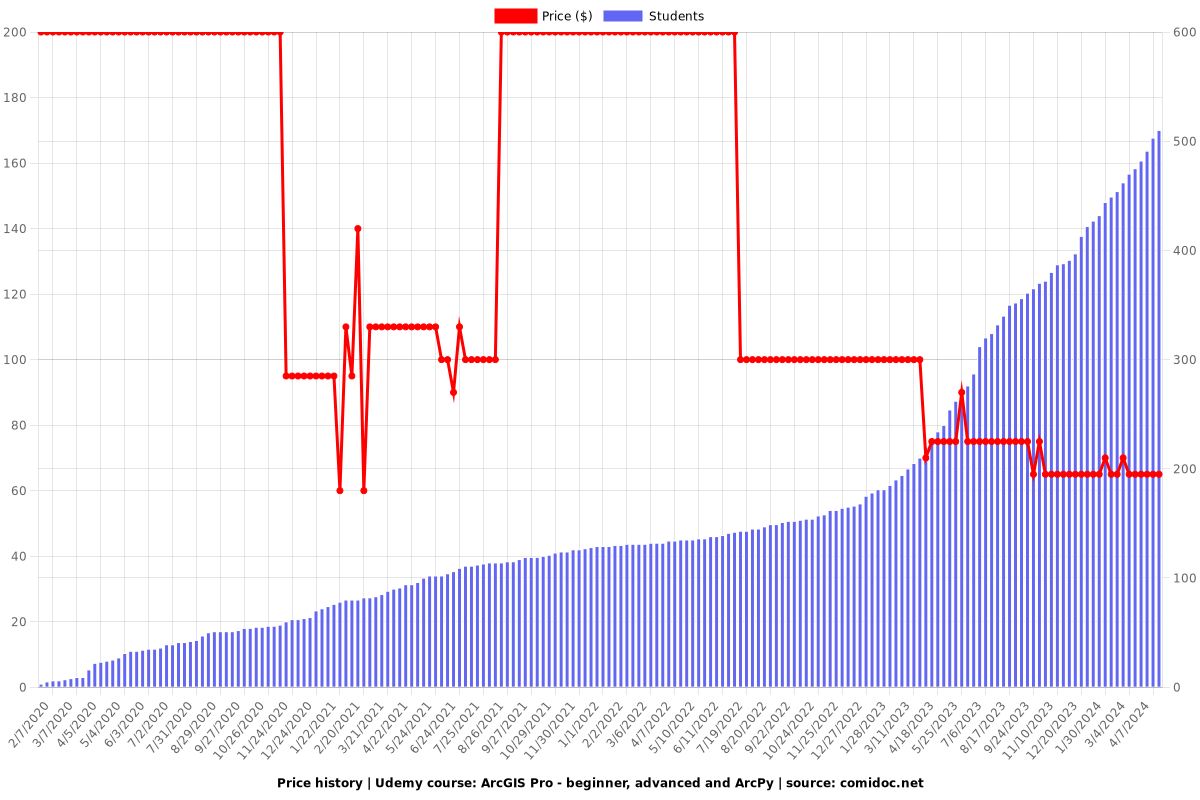
Price
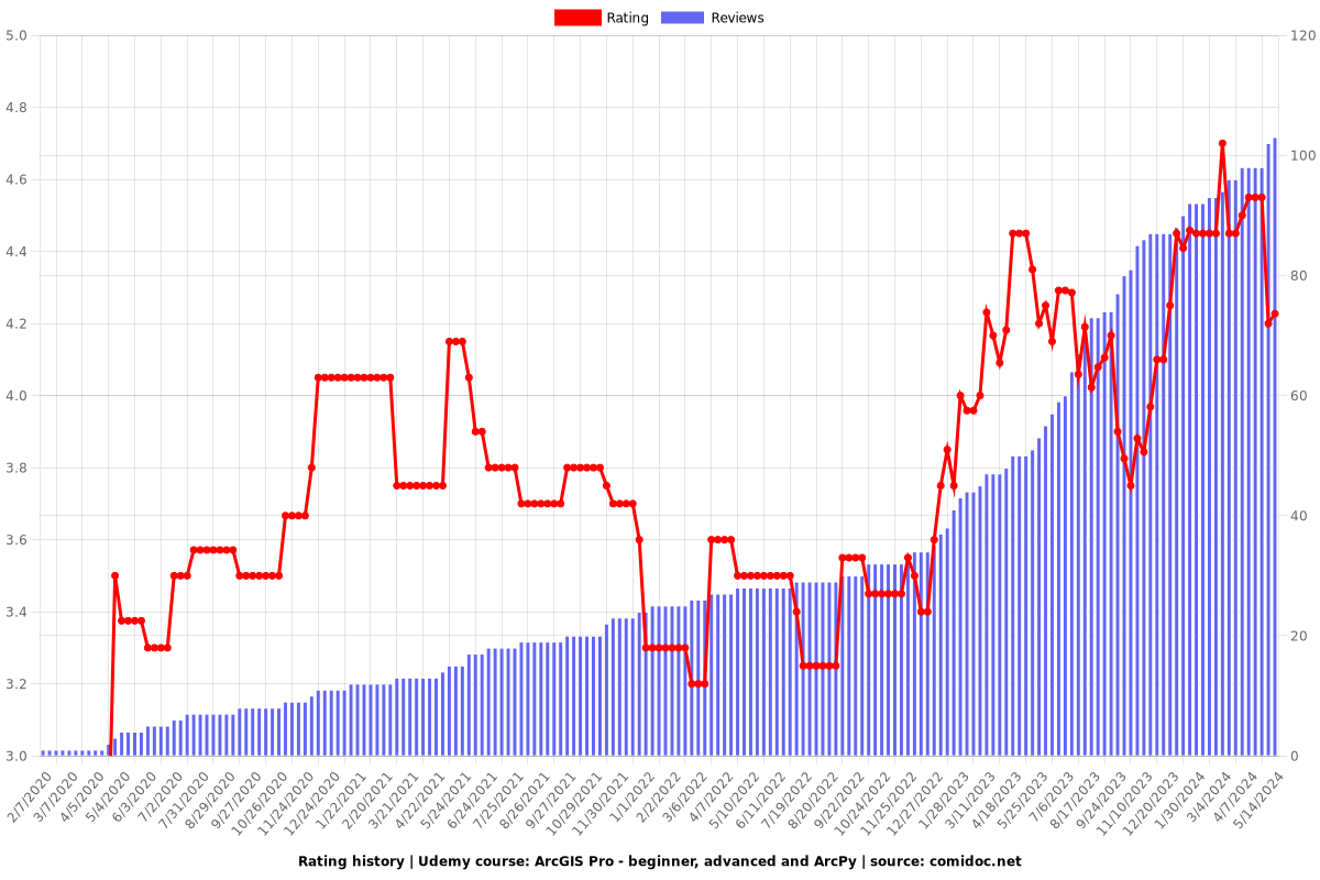
Rating
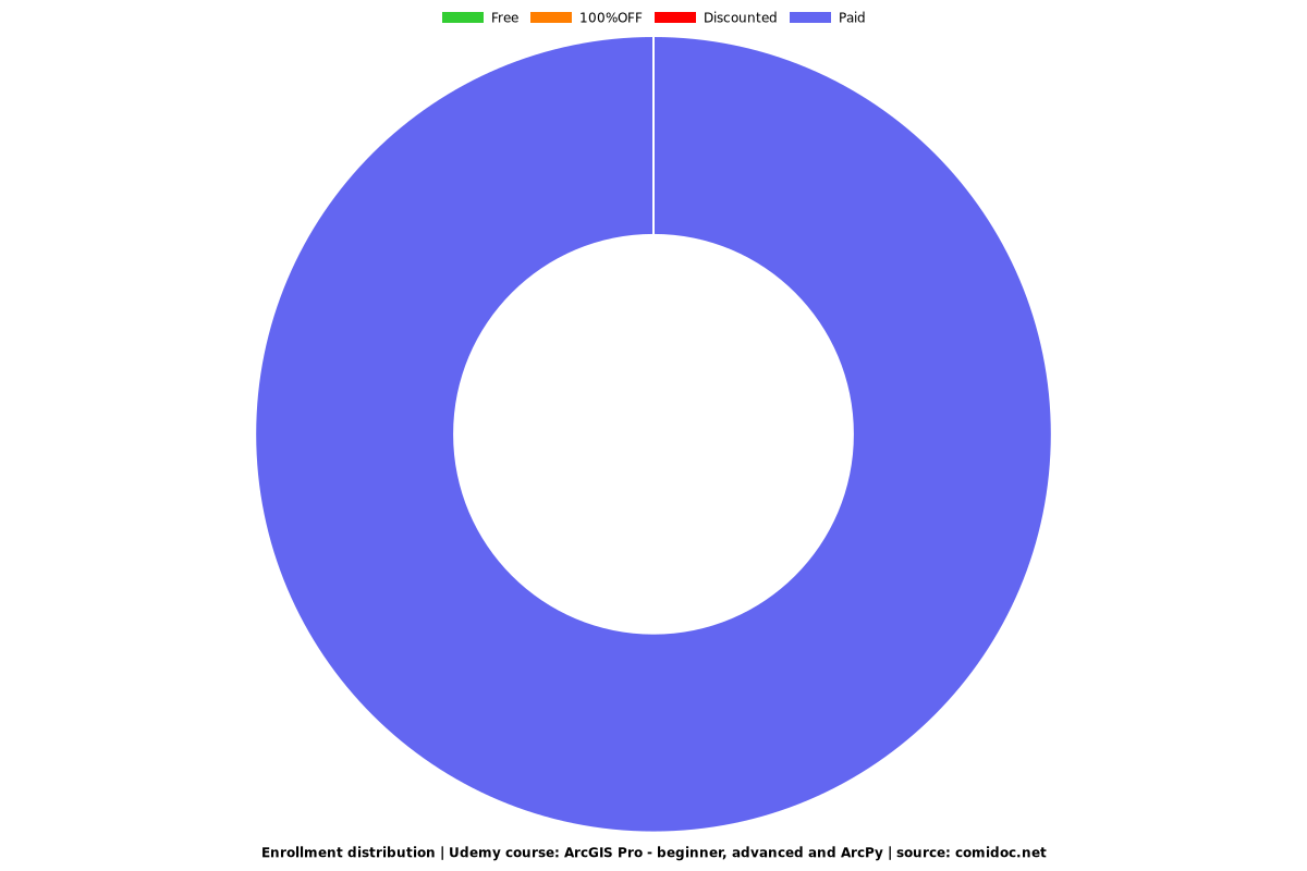
Enrollment distribution