Satellite Remote Sensing Data Bootcamp With Opensource Tools

Pre-process and Analyze Satellite Remote Sensing Data With Free Software

4.80 (361 reviews)
Udemy
platform
English
language
Science
category
instructor
Satellite Remote Sensing Data Bootcamp With Opensource Tools
2,736
students
4 hours
content
Nov 2023
last update
$79.99
regular price

What you will learn

Download different types of satellite remote sesning data for free

Have thorough knowledge of remote sensing- theoretical concepts and applications

Implement pre-processing techniques using R and QGIS

Carry out unsupervised classification of satellite remote sesning data

Carry out supervised classification of satellite remote sesning data

Implement machine learning algorithms on satellite remote sensing data in R

Carry out habitat suitability mapping using remote sensing and machine learning

Use other freely avaliable software tools such as Google Earth Engine and SNAP for RS data analysis

Why take this course?

ENROLL IN MY LATEST COURSE ON HOW TO LEARN ALL ABOUT BASIC SATELLITE REMOTE SENSING.

Are you currently enrolled in either of my Core or Intermediate Spatial Data Analysis Courses?

Or perhaps you have prior experience in GIS or tools like R and QGIS?

You don't want to spend 100s and 1000s of dollars on buying commercial software for imagery analysis?

The next step for you is to gain profIciency in satellite remote sensing data analysis.

MY COURSE IS A HANDS ON TRAINING WITH REAL REMOTE SENSING DATA WITH OPEN SOURCE TOOLS!

My course provides a foundation to carry out PRACTICAL, real-life remote sensing analysis tasks in popular and FREE software frameworks with REAL spatial data. By taking this course, you are taking an important step forward in your GIS journey to become an expert in geospatial analysis.

Why Should You Take My Course?

I am an Oxford University MPhil (Geography and Environment) graduate. I also completed a PhD at Cambridge University (Tropical Ecology and Conservation).

I have several years of experience in analyzing real life spatial remote sensing data from different sources and producing publications for international peer reviewed journals.

In this course, actual satellite remote sensing data such as Landsat from USGS and radar data from JAXA  will be used to give a practical hands-on experience of working with remote sensing and understanding what kind of questions remote  sensing can help us answer.

This course will ensure you learn & put remote sensing data analysis into practice today and increase your proficiency in geospatial analysis.

Remote sensing software tools are very expensive and their cost can run into thousands of dollars. Instead of shelling out so much money or procuring pirated copies (which puts you at a risk of prosecution), you will learn to carry out some of the most important and common remote sensing analysis tasks using a number of popular, open source GIS tools such as R, QGIS, GRASS and ESA-SNAP.  All of which are in great demand in the geospatial sector and improving your skills in these is a plus for you.

This is an introductory course, i.e. we will focus on learning the most important and widely encountered remote sensing data processing and analyzing tasks in R, QGIS, GRASS and ESA-SNAP

You will also learn about the different sources of remote sensing data there are and how to obtain these FREE OF CHARGE and process them using FREE SOFTWARE.

In addition to all the above, you’ll have MY CONTINUOUS SUPPORT to make sure you get the most value out of your investment!

ENROLL NOW :)

Screenshots

Satellite Remote Sensing Data Bootcamp With Opensource Tools - Screenshot_01Satellite Remote Sensing Data Bootcamp With Opensource Tools - Screenshot_02Satellite Remote Sensing Data Bootcamp With Opensource Tools - Screenshot_03Satellite Remote Sensing Data Bootcamp With Opensource Tools - Screenshot_04

Our review

--- **Overview of Course "Remote Sensing with Free Tools: An Introduction"** The global course rating stands at an impressive **4.80**, with all recent reviews painting a picture of a highly beneficial and informative course for those interested in the field of remote sensing. The majority of the reviews commend the course's focus on free tools such as R, and the clarity with which the concepts are explained through real-world examples and comprehensive workflow diagrams. **Pros:** - **Comprehensive Introduction to Free Tools**: The course is lauded for its introduction to various free tools like R, ESA SNAP, and others, which are essential for remote sensing analysis. - **Real Data Application**: Participants appreciate the use of real data in well-selected examples that illustrate important concepts. - **Knowledgeable Instructor**: The instructor's deep understanding of the subject matter is consistently highlighted across reviews. - **Practical Workflow Diagrams**: The course provides valuable workflow diagrams that are structured to guide beginners through the process of working with satellite data. - **Engaging and Clear Communication**: The instructor's delivery is described as engaging, thorough, and full of clarity, which facilitates understanding and learning. - **Machine Learning Insights**: The course offers a helpful introduction to machine learning methods, providing context for their application in remote sensing analysis. - **Useful for Practical Application**: Many reviewers indicate that the knowledge gained from this course will be directly applicable to their work and projects. - **Well-Structured Course Content**: The course is characterized as well-structured and beneficial for those looking to expand their skills in satellite remote sensing data analysis. **Cons:** - **Follow-Along Materials**: Some learners feel that there could be more assignments or examples to follow along with, beyond watching the instructor's demonstrations. - **Data File Correspondence**: A few reviews mention some confusion regarding the correspondence of lecture data files with those provided for practice. - **Technical Issues**: One review notes issues with black screens in certain sessions, which could potentially disrupt the learning experience. - **Software and Data Updates**: There are concerns about the course content staying current, as some tools (like R packages) and data sources (like Landsat Collection 1) are no longer supported or available as taught in the course. - **Organization of Materials**: The suggestion is made for a dedicated folder or repository for all relevant R codes to aid in following along with the course content. **Additional Notes:** - **Community Feedback**: The course has received positive feedback from learners who have found it useful and engaging, with some expressing gratitude towards Minerva Singh and the Udemy team for their efforts. - **Course Versatility**: Several reviews emphasize the versatility of the course material, noting its potential for a wide range of applications in satellite remote sensing data analysis. In conclusion, this course is highly recommended for individuals interested in remote sensing and looking to utilize free tools such as R. While there are some technical and content updates needed to ensure the materials remain relevant, the overall sentiment from learners is overwhelmingly positive, citing its educational value and the clarity with which complex concepts are taught. ---

Charts

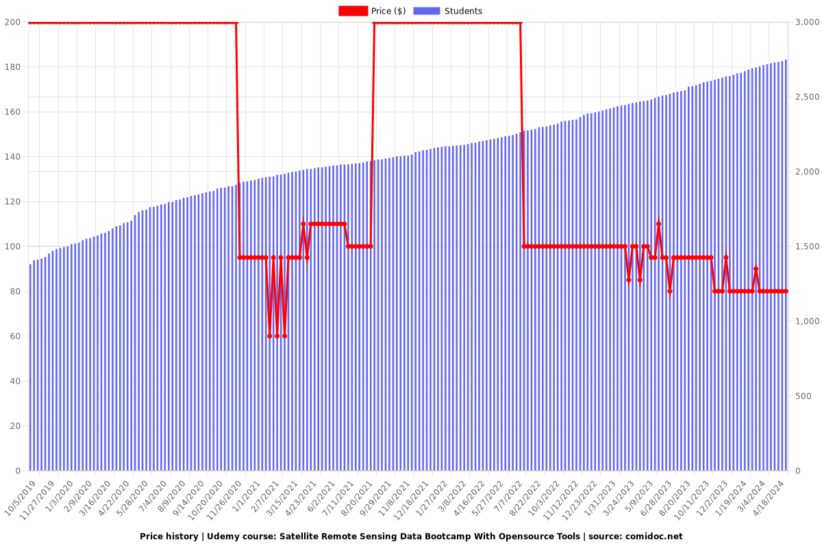
Price

Satellite Remote Sensing Data Bootcamp With Opensource Tools - Price chart

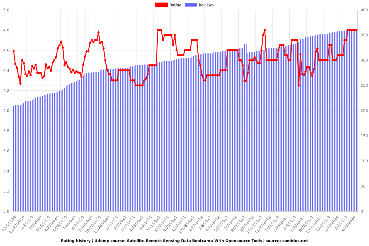
Rating

Satellite Remote Sensing Data Bootcamp With Opensource Tools - Ratings chart

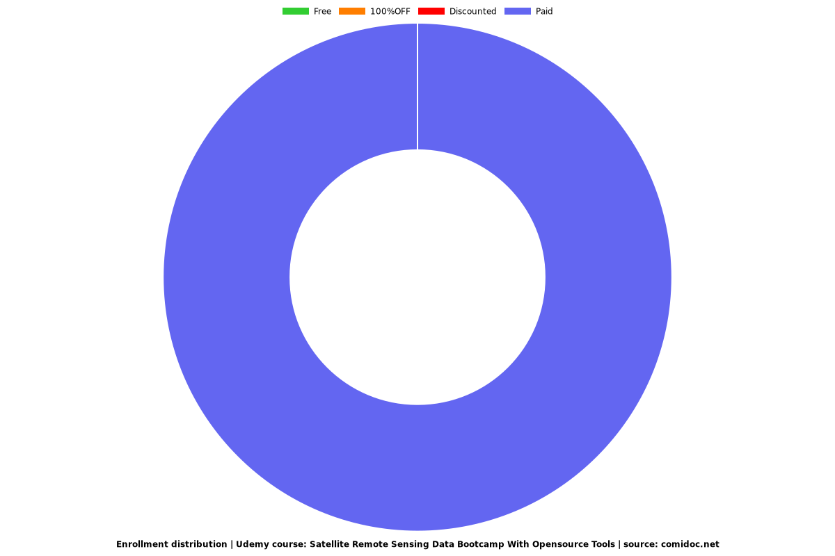
Enrollment distribution

Satellite Remote Sensing Data Bootcamp With Opensource Tools - Distribution chart
1161866
udemy ID
3/29/2017
course created date
10/5/2019
course indexed date
Bot
course submited by